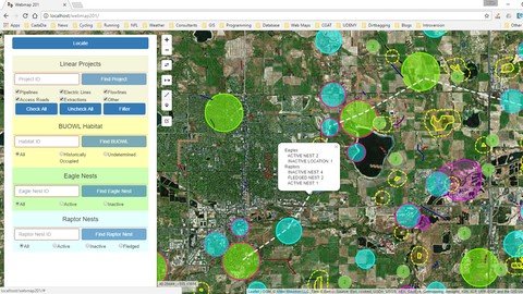
Display And Analyze Gis Data On The Web With Leaflet
Last updated 11/2019
MP4 | Video: h264, 1280x720 | Audio: AAC, 44.1 KHz
Language: English | Size: 2.53 GB | Duration: 13h 43m
Client side mapping applications with the open source jаvascript libraries Leaflet.js and Turf.js
What you'll learn
Learn to find and zoom to your position on a map
Learn to use leaflet controls for user interface, geocoding, editing, and loading data
Learn what background maps are available and how to use them
Learn to create vector data and style it in your map
Learn how to export your GIS data to GeoJSON format and load it into the map
Learn how to filter a subset of your data
Learn how to search for specific data elements and view their attributes
Learn how to analyze spatial relationships
Much, much, more!
Requirements
This course has a prerequisite called Introduction to Web Programming for GIS Applications. I assume that students will be familiar with the subject matter of that course up to at least Lesson 61.
If you have some familiarity withHTML, CSS, jQuery, Bootstrap, jаvascript, and GIS you should be able to take this course without the prerequisite but I am basing this course on that level of knowledge.
Description
"This is a great and advanced web mapping application course to solve real world problem. It's very to follow up and the instructor is very knowledgeable. I would recommend it to anyone who is interested in the field webmapping. Thanks Michael."
"Very nice course on using leaflet to build web maps. Many aspects of leaflet and leaflet plugins are covered along with some more advanced analysis using turf. The code examples are helpful in getting started with leaflet maps and adding widgets for interacting with the map."
This course will provide you with the knowledge you need to
create a Leaflet web mapadd map controls choose from a variety of background mapsadd your own GIS to itstyle your datafind specific dataanalyze spatial relationships
At the end of the course you will be able to create web interfaces to view, search, and analyze your GIS data and make them accessible to anyone with a web interface for free!This course requires only a text editor and an open source web server to get started designing web GIS applications.
Overview
Section 1: Introduction
Lecture 1 Introduction
Lecture 2 Optional - About Me
Lecture 3 Client-Server Architecture
Lecture 4 Required software for this course
Lecture 5 Anatomy of a URL
Lecture 6 Your first web map - Setup
Lecture 7 Your first web map - Code
Lecture 8 Leaflet documentation - Part 1
Lecture 9 Leaflet documentation - Part 2
Lecture 10 Leaflet Plug-ins
Lecture 11 Optional - Editors
Section 2: The Leaflet Map Object
Lecture 12 The Leaflet Map Object - Part 1
Lecture 13 The Leaflet Map Object - Part 2
Lecture 14 The Leaflet location method
Lecture 15 Connecting the map object to the DOM
Lecture 16 Leaflet popups
Lecture 17 Native Leaflet controls
Lecture 18 Plugin Leaflet controls - Part 1
Lecture 19 Plugin Leaflet controls - Part 2
Lecture 20 Plugin Leaflet controls - Part 3
Lecture 21 Plugin Leaflet controls - Part 4
Lecture 22 Plugin Leaflet controls - Part 5
Section 3: Raster layers in Leaflet
Lecture 23 Introduction to layers
Lecture 24 Leaflet basemaps
Lecture 25 The layer control
Lecture 26 Raster overlays
Section 4: Vector layers in Leaflet
Lecture 27 Introduction to vector layers
Lecture 28 The marker object
Lecture 29 The path and polyline objects
Lecture 30 The polygon object
Lecture 31 Layer groups
Lecture 32 Leaflet Draw Plugin
Lecture 33 Optional - GeoJSON Review
Lecture 34 Working with geoJSON in Leaflet
Lecture 35 The Leaflet.AJAX plugin
Lecture 36 Other sources of vector data
Section 5: Styling vector data
Lecture 37 Native Leaflet marker styles - Part 1
Lecture 38 Native Leaflet marker styles - Part 2
Lecture 39 Plugin Leaflet marker styles
Lecture 40 Creating your own custom markers
Lecture 41 De-cluttering your markers with the markercluster plugin
Lecture 42 Native Leaflet options for styling lines and polygons
Lecture 43 Plugin options for styling lines and polygons
Lecture 44 Optional - Colors on the web
Section 6: Searching, filtering, and analyzing data in Leaflet
Lecture 45 Introduction and organizing previous code
Lecture 46 Building a search box in Leaflet - HTML and CSS
Lecture 47 Building a search box in Leaflet - jаvascript
Lecture 48 Building a search box in Leaflet - Autocomplete part 1
Lecture 49 Building a search box in Leaflet - Autocomplete part 2
Lecture 50 Generalizing functions
Lecture 51 Filtering data - radio boxes
Lecture 52 Filtering data - check boxes
Lecture 53 Editing geometry in Leaflet
Lecture 54 Finding Nearest Feature - Part 1
Lecture 55 Finding nearest feature - Part 2
Section 7: Analyzing data with Turf.js in Leaflet
Lecture 56 Introduction to Turf.js - Buffers
Lecture 57 Buffering based on feature attribute
Lecture 58 Spatial analysis - Point in Polygon
Lecture 59 Spatial analysis - Filtering a feature class
Lecture 60 Spatial Analysis - Intersecting polygons
Lecture 61 Spatial Analysis - Summarizing polygon feature collections
Lecture 62 Spatial Analysis - Intersecting lines with polygons
Lecture 63 Summary
Section 8: Bonus Material
Lecture 64 Designing for mobile applications
Lecture 65 Bonus Project - Diversity Calculator
Lecture 66 Taking your application live
Lecture 67 Legends in Leaflet (Pt1)
Lecture 68 Legends in Leaflet (Pt 2)
Lecture 69 Legends in Leaflet (Pt 3)
Lecture 70 QGIS2Web - Get a jump start on your leaflet map creation.
Lecture 71 Bonus Lecture: How to get the most from my series of Udemy courses.
This course is oriented towards GIS professionals who are interested in expanding their skill sets to display and analyze their data on the web. I use open source software to make the material available to everyone free of charge but many of the concepts will be useful for commercial jаvascript API's as well. This course will also be useful for Web Developers who want to learn to add maps to their projects with leaflet.
Homepage
https://www.udemy.com/course/display-and-analyze-gis-data-on-the-web/Fikper
tgogl.Display.And.Analyze.Gis.Data.On.The.Web.With.Leaflet.part1.rar.html
tgogl.Display.And.Analyze.Gis.Data.On.The.Web.With.Leaflet.part2.rar.html
tgogl.Display.And.Analyze.Gis.Data.On.The.Web.With.Leaflet.part3.rar.html

tgogl.Display.And.Analyze.Gis.Data.On.The.Web.With.Leaflet.part1.rar.html
tgogl.Display.And.Analyze.Gis.Data.On.The.Web.With.Leaflet.part2.rar.html
tgogl.Display.And.Analyze.Gis.Data.On.The.Web.With.Leaflet.part3.rar.html

tgogl.Display.And.Analyze.Gis.Data.On.The.Web.With.Leaflet.part1.rar
tgogl.Display.And.Analyze.Gis.Data.On.The.Web.With.Leaflet.part2.rar
tgogl.Display.And.Analyze.Gis.Data.On.The.Web.With.Leaflet.part3.rar

tgogl.Display.And.Analyze.Gis.Data.On.The.Web.With.Leaflet.part1.rar
tgogl.Display.And.Analyze.Gis.Data.On.The.Web.With.Leaflet.part2.rar
tgogl.Display.And.Analyze.Gis.Data.On.The.Web.With.Leaflet.part3.rar
Links are Interchangeable - No Password - Single Extraction